Berlin under the swastika: a self-guided walking tour of key Third Reich sites
Berlin: Third Reich Tour — Under the Swastika
Which are the most significant Third Reich sites still visible in central Berlin?
The core sites are the Topography of Terror (former Gestapo and SS headquarters), the Memorial to the Murdered Jews of Europe, the Neue Wache, the Bebelplatz book burning site, the Reich Chancellery area (now beneath the car park near the Führerbunker), and the Olympic Stadium. Most are within walking distance of each other in Mitte and Kreuzberg.
Which are the most significant Third Reich sites still visible in central Berlin? The Topography of Terror (former Gestapo and SS headquarters), the Holocaust Memorial, the Bebelplatz book burning site, the Führerbunker location, and the Neue Wache are all within a roughly 3 km radius of each other in Mitte and southern Mitte/Kreuzberg. Walking between them reveals how the Nazi government district was spatially organised — and how postwar Berlin has chosen to memorialise, obscure, and reclaim these addresses.
This guide presents a coherent walking route with historical context. It is not designed as entertainment but as orientation for those who want to understand Berlin’s Nazi period through the physical geography that remains.
Before you walk — what the district looked like in 1938
The central Berlin of the Third Reich was substantially different from the city you walk through today. Albert Speer, appointed General Building Inspector (Generalbauinspektor) by Hitler in 1937, had plans to demolish most of Mitte and rebuild it as “Germania” — a new imperial capital on a scale that would make Rome and Paris appear modest.
The proposed north-south Prachtstrasse (Grand Boulevard) would have run 7 km through the city, 120 metres wide, anchored at one end by a triumphal arch and at the other by the Volkshalle — a domed assembly hall with capacity for 180,000 standing, so large that clouds would have formed inside it from crowd condensation. These plans were abandoned when the war turned against Germany, but models survive in the German Historical Museum.
What the Third Reich did build in central Berlin, between 1933 and 1939, was a concentration of power along Wilhelmstrasse and Voßstrasse that made this district the administrative centre of a genocidal state. Walking it today, most of the buildings are gone. But the street plan largely survives, and the addresses are real.
The walking route — six stops
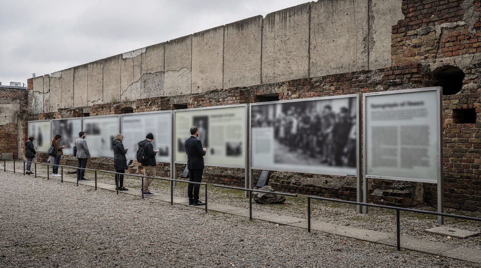
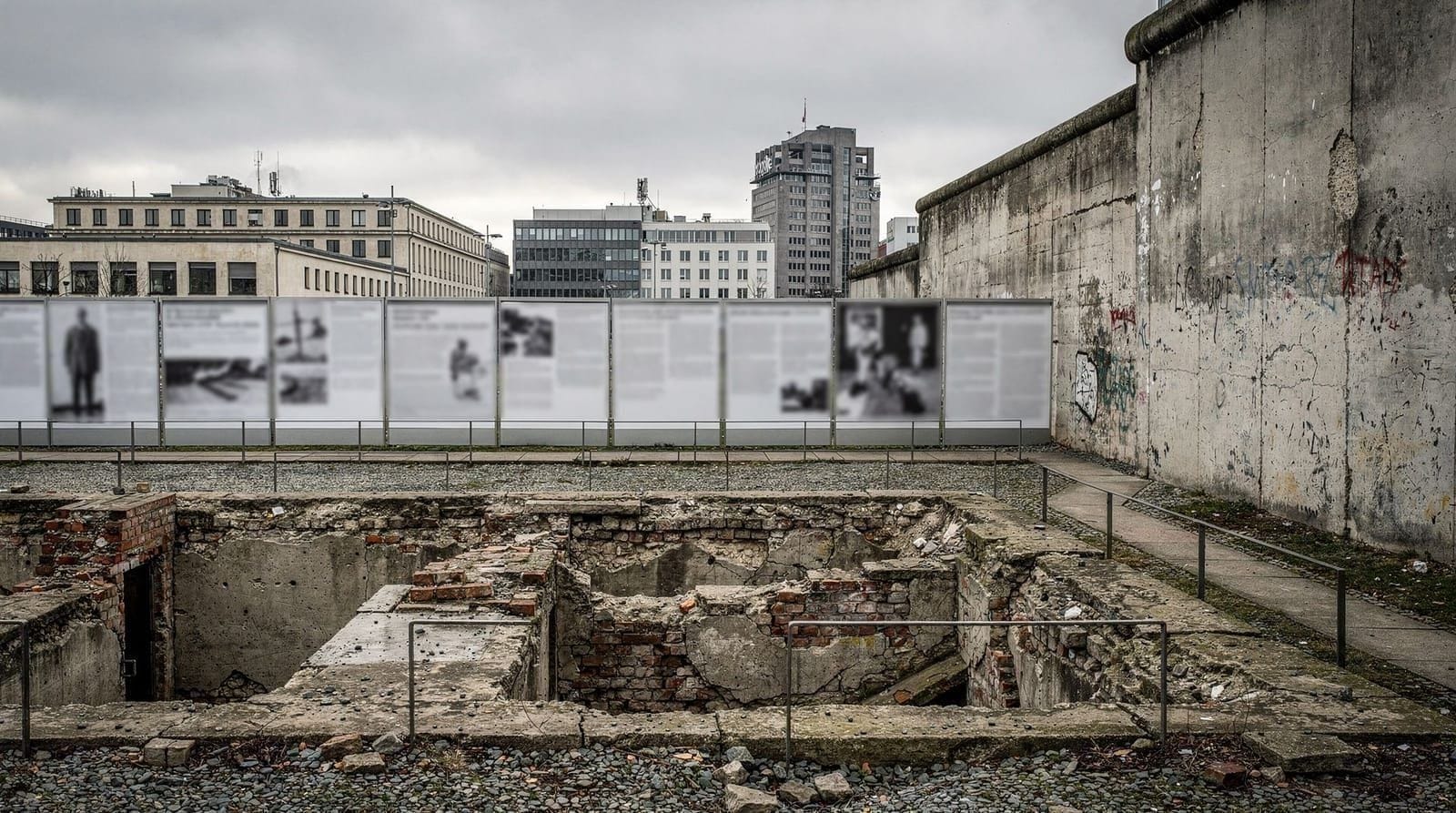
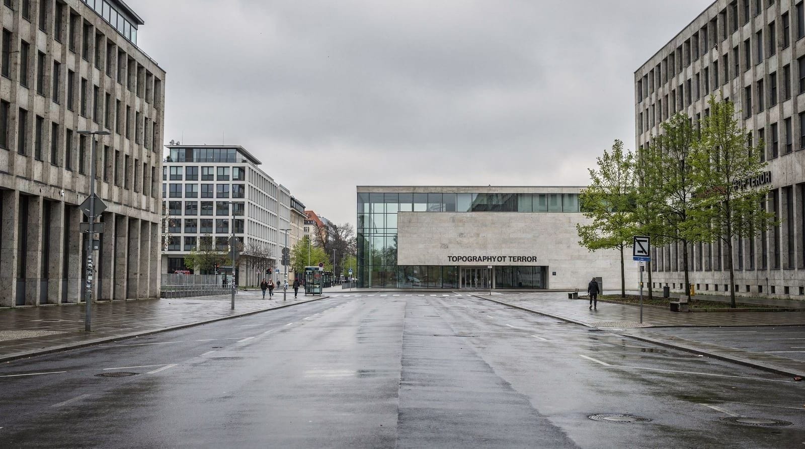
Stop 1: Topography of Terror, Niederkirchnerstrasse 8
Start here. Allow 2–2.5 hours.
The Topography of Terror occupies the excavated foundations of the former Gestapo headquarters (Prinz-Albrecht-Strasse 8) and the adjacent SS main office complex. The indoor documentation centre is free, open daily 10:00–20:00.
The outdoor exhibition runs along Niederkirchnerstrasse (the former Prinz-Albrecht-Strasse) beside a surviving section of the Berlin Wall. The pairing is deliberate and historically significant: the Wall was built on top of the Nazi ruins.
The exhibition documents not just who the Gestapo was but how it worked — including the central role of citizen denunciations. It is the most comprehensive free introduction to the Nazi security apparatus available to the public. Read the panels on the deportation of Berlin’s Jewish community, the persecution of political opponents, and the specific prisoners held in the basement cells.
For the full history of the site, see the Gestapo headquarters history guide.
Getting there: U6 Kochstrasse (3 min walk), or S1/S2 Anhalter Bahnhof (6 min walk).
Stop 2: Führerbunker area and former Reich Chancellery, In den Ministergärten
From the Topography of Terror, walk north along Wilhelmstrasse approximately 650 metres. Allow 20–30 minutes.
Nothing above ground marks this area explicitly. The approximate location of Hitler’s Führerbunker — where he remained from January 16, 1945 until his death on April 30, 1945 — is now beneath a car park and apartment blocks near the junction of Gertrud-Kolmar-Strasse and In den Ministergärten.
A small, easily-missed information panel (Gedenkstätte information board) near the car park entrance gives the historical outline. The decision not to create a significant memorial here was deliberate: the concern about neo-Nazi pilgrimage overrode other considerations. The result is one of the more peculiar examples of absence-as-memorial in the city.
The New Reich Chancellery, designed by Speer and built in nine months in 1938–1939, ran along Voßstrasse from Wilhelmstrasse west to Hermann-Göring-Strasse. It was demolished between 1945 and 1949 by Soviet engineers, who used its marble for Treptower Park. The road itself is now called Voßstrasse, and the footprint of the Chancellery garden — where the bunker entrance was — is now beneath the residential blocks on Gertrud-Kolmar-Strasse.
Standing at this corner in 2026, in a quiet neighbourhood, is itself a form of historical information. The deliberate erasure of the site is part of the postwar story.
For a detailed account, see the Führerbunker history guide.
Stop 3: Memorial to the Murdered Jews of Europe (Holocaust Memorial), Cora-Berliner-Strasse
From the Führerbunker area, walk 200 metres north. Allow 30–45 minutes.
The Memorial to the Murdered Jews of Europe (officially: Denkmal für die ermordeten Juden Europas) opened in 2005. Designed by Peter Eisenman, it occupies 19,073 square metres directly south of the Brandenburg Gate with 2,711 concrete stelae (pillars) of varying heights arranged in a sloping grid.
The design creates an immediate perceptual effect: entering the field from the edges, the undulating ground and varying heights of the stelae create a sense of disorientation and isolation. The sound of the city fades; pathways disappear. Some visitors find this powerful; others find it abstract.
The underground information centre (Ort der Information) beneath the memorial provides the specific historical content that the outdoor stelae deliberately withhold. The centre documents the stages of persecution and extermination, with rooms dedicated to individual victims’ stories, to family histories, and to sites of mass murder across Europe. Entry is free; lines can be long in peak season — arrive early.
The memorial’s location — on what was, until 1989, West Berlin near the Wall, directly adjacent to the former SS garden and the empty ground of the Reich Chancellery — is a carefully considered spatial argument about memory and responsibility.
See the Holocaust Memorial guide for detailed visiting information.
Stop 4: Brandenburg Gate and the former government district, Pariser Platz
Walk 400 metres north. Allow 15–20 minutes.
The Brandenburg Gate stands at the western end of Unter den Linden, at the point where the royal processional avenue meets the Tiergarten. Built 1788–1791, it predates the Nazi period by 140 years. The Nazis used it for ceremonial purposes — the torchlight parade on January 30, 1933 after Hitler’s appointment as Chancellor passed through the Gate — but it is not a Nazi monument.
The surrounding Pariser Platz, largely destroyed in the war and rebuilt after 1990, now hosts the French Embassy, the DZ Bank (designed by Frank Gehry), the Academy of Arts, the Adlon Hotel (rebuilt 1997), and the American Embassy. On January 30, 1933, Hitler watched the torchlight parade from a window of the Chancellery building on Wilhelmstrasse.
Look south from the Gate: the stelae of the Holocaust Memorial are visible in the middle ground. This juxtaposition — state power and memorial — is the contemporary city’s spatial argument.
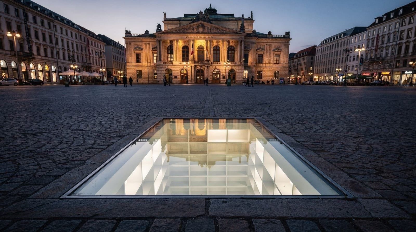
Stop 5: Bebelplatz book burning site, Unter den Linden
Walk east along Unter den Linden approximately 800 metres. Allow 15–20 minutes.
Bebelplatz is the square on the south side of Unter den Linden, directly in front of the Humboldt University law faculty. On 10 May 1933, Nazi students organised the burning of approximately 20,000 books by authors deemed “un-German” — including Sigmund Freud, Karl Marx, Heinrich Heine, Bertolt Brecht, Erich Maria Remarque, and Magnus Hirschfeld (whose Institut für Sexualwissenschaft, the world’s first sexology research institute, was also destroyed in the same week).
The memorial (1995) by Israeli sculptor Micha Ullman is a glass panel set flush in the paving of the square. Through it, you see a white underground library with empty shelves — capacity approximately 20,000 volumes. The effect is quiet and precise. Look for it in the centre of the square; it is easy to walk over.
Heinrich Heine’s quotation — “Das war ein Vorspiel nur, dort wo man Bücher verbrennt, verbrennt man auch am Ende Menschen” (“That was only a prelude; where books are burned, people are eventually burned as well”), written in 1820 — is inscribed on a plaque nearby. Heine’s books were among those burned in 1933.
The surrounding buildings — Humboldt University (attended by, among others, Marx, Engels, Einstein, and Hegel), the Staatsoper Unter den Linden, the Alte Bibliothek (former royal library) — are all pre-Nazi Prussian institutions, giving the square its particular historical layering.
See the Bebelplatz book burning guide for further detail.
Stop 6: Neue Wache, Unter den Linden 4
Continue 200 metres east along Unter den Linden. Allow 15 minutes.
The Neue Wache (New Guardhouse), a Karl Friedrich Schinkel neoclassical building of 1818, has served as Germany’s central memorial to the victims of war and tyranny since 1993. It is a small building — a single chamber with an oculus open to the sky — but the Käthe Kollwitz Pietà sculpture at its centre (an enlarged bronze cast of Kollwitz’s small 1937 original) is among the most emotionally affecting memorials in Berlin.
The inscription reads: “To the victims of war and tyranny” (Den Opfern von Krieg und Gewaltherrschaft). The expanded category — “tyranny,” not just “war” — encompasses both Nazi and GDR victims, which has generated debate about whether perpetrators and victims are adequately distinguished.
Entry is free. The building is open daily 10:00–18:00.
For full historical context, see the Neue Wache memorial guide.
Berlin under the swastika guided walking tour — key Third Reich sites with historical commentaryPractical planning for the route
Total walking distance: Approximately 3.5 km between all six stops.
Total time: 5–6 hours including interior visits to the Topography of Terror and Holocaust Memorial information centre, and exterior visits to all other sites.
Best time: Mornings on weekdays. The Topography of Terror and Holocaust Memorial are less crowded before noon.
Transport: Start at U6/S-Bahn Anhalter Bahnhof or U6 Kochstrasse for Stop 1. End at U6 Französische Strasse (near Bebelplatz) or walk to S-Bahn Hackescher Markt.
Food and water: Bring water and a small snack — the route has limited food stops. There are cafés along Unter den Linden if needed. Avoid eating lunch at the Holocaust Memorial; this is occasionally done by tourists and is considered inappropriate by most observers.
Guided tour of Berlin’s most significant Third Reich sites — with licensed historianA note on tone and approach
These are sites where the worst crimes in modern European history were planned and administered. Berlin has built much of its contemporary cultural identity around honest engagement with this history — more so, arguably, than any other capital city in the world. The Topography of Terror, the Holocaust Memorial, the Neue Wache, and the Bebelplatz memorial are serious places, designed to be visited attentively.
Selfies at the Holocaust Memorial, particularly those involving jumping between the stelae or performing comedy, are widely criticised and have generated public debate. The photography project “Yolocaust” by Shahak Shapiro (2017) superimposed Holocaust images onto selfies taken at the memorial; the subsequent controversy clarified where most Berliners draw the line.
Walking this route thoughtfully — reading panels, allowing time, following a coherent historical narrative rather than collecting sights — is both more respectful and, for most visitors, considerably more valuable.
For a structured two-to-three-day itinerary combining this route with Sachsenhausen and the Wannsee Conference Memorial, see the third-Reich history trail.
Frequently asked questions about Berlin under the swastika
How long does a Third Reich walking tour of Berlin take?
A focused route covering the Topography of Terror, Führerbunker area, Reich Chancellery foundations, Holocaust Memorial, Brandenburg Gate, and Bebelplatz takes approximately 4–5 hours at a walking pace with time to read information panels. The Reichstag (exterior) and government district add another hour. Allow a full day to visit site interiors as well.Are Third Reich sites in Berlin appropriate to visit?
Yes. Visiting sites of historical atrocity, treated with appropriate solemnity, is a legitimate and important form of historical education. Berlin has built its post-war identity around honest engagement with this history. Most sites are free and intentionally designed for the public. The appropriate approach is attentive, factual, and respectful — the same you would bring to any major memorial site.What remains of the Reich Chancellery in Berlin?
Nothing above ground. The New Reich Chancellery on Voßstrasse, completed by Albert Speer in 1939, was demolished by Soviet engineers in 1945–1949. The marble from its interiors was used to clad the Soviet War Memorial at Treptower Park. The only remaining traces are foundations occasionally uncovered during construction. The approximate footprint is now a residential area near In den Ministergärten, adjacent to the Holocaust Memorial.What is the Führerbunker and can you visit it?
The Führerbunker was Hitler's underground command complex beneath the garden of the New Reich Chancellery, where he spent the final months of the war and died on 30 April 1945. The bunker was damaged by Soviet engineers and progressively sealed. A small information panel near the junction of In den Ministergärten and Gertrud-Kolmar-Strasse marks the approximate location. No public access to the structure itself exists — a deliberate decision to avoid the site becoming a pilgrimage point for neo-Nazis.What was Bebelplatz and what happened there?
Bebelplatz is a square on Unter den Linden, opposite Humboldt University. On 10 May 1933, Nazi students burned approximately 20,000 books by Jewish, communist, and politically undesirable authors in what they termed an Aktion gegen den undeutschen Geist. The site now has a memorial by Micha Ullman — a glass panel in the paving through which you can see empty white bookshelves, lit from below. Heine's inscription "Where books are burned, people are burned in the end" is engraved nearby.Is the Brandenburg Gate a Nazi monument?
No. The Brandenburg Gate was built in 1791 under Frederick William II of Prussia, long before the Nazi era. The Nazis used it extensively for ceremonial purposes and it appears in regime propaganda, but its origin and primary historical significance are pre-Nazi. It is a symbol of German division and reunification in the Cold War context — see the Berlin divided city history guide for that dimension.Which guided tours cover the Third Reich walking route well?
The best guided tours focus specifically on the Nazi period rather than mixing Cold War, contemporary, and Nazi history into one circuit. Look for tours of 3–4 hours minimum with licensed historians rather than general city guides. Tours starting at the Topography of Terror and working through the government district tend to be the most coherent.
Top experiences
Bookable activities with verified prices and instant confirmation on GetYourGuide.