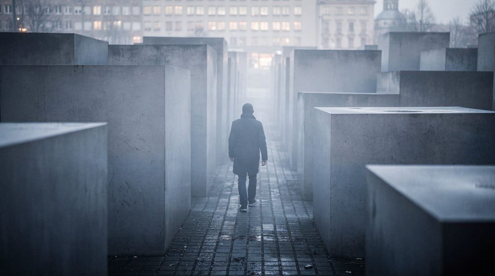
WWII bombing traces in Berlin: ruins, bullet holes, and surviving damage visible today
Where can you still see WWII bombing damage in Berlin today?
The most visible site is the Kaiser Wilhelm Memorial Church in Charlottenburg, deliberately left as a ruin. Bullet holes remain on numerous buildings in Mitte and Prenzlauer Berg. The Soviet War Memorial at Treptower Park incorporates marble from the Reich Chancellery. Numerous street-level traces — shrapnel scars, patched stonework, abrupt changes in building fabric — are visible throughout the city.
Where can you still see WWII bombing damage in Berlin today? The Kaiser Wilhelm Memorial Church ruin in Charlottenburg is the most deliberate preservation of war damage. Bullet holes remain on pre-war building facades across Mitte, Prenzlauer Berg, and Friedrichshain. The artificial rubble mountains (Trümmerberge) of the Grunewald and Volkspark Friedrichshain are the compacted remains of 75 million cubic metres of debris. Looking for these traces — once you know what to look for — transforms how you read the city.
The scale of destruction — what the bombing did to Berlin
The Allied strategic bombing campaign against Berlin began seriously in November 1943, when RAF Bomber Command under Arthur Harris launched a series of attacks intended to destroy the city. Between November 1943 and March 1944, 16 major RAF raids on Berlin dropped approximately 50,000 tonnes of bombs. US Army Air Forces conducted additional daylight raids from March 1944 through the end of the war.
The bombing targeted industrial, transport, and administrative infrastructure but was not precision bombing in the modern sense — the accuracy of high-altitude night bombing in 1943–1944 meant that residential districts were destroyed alongside military targets. The raids on November 22–23, 1943 destroyed approximately 2,500 hectares of the western city, including Charlottenburg and parts of Tiergarten.
By war’s end, estimates suggest 40 percent of Berlin’s building stock was destroyed or heavily damaged. In the innermost districts — Mitte, Tiergarten, Prenzlauer Berg — destruction reached 80 percent or higher. The central government district along Wilhelmstrasse and Voßstrasse was levelled. The historic core around the Schlossplatz and Museum Island was gutted.
Then came the Battle of Berlin. From April 16 to May 2, 1945, Soviet forces fought building by building through the city. Artillery, tank fire, infantry weapons, and Panzerfaust rounds added to what the bombs had done. The Reichstag was assaulted on May 1; the Brandenburg Gate was hit by Soviet artillery; the S-Bahn tunnels were flooded when SS engineers blew the Landwehr Canal floodgates in a final defensive measure.
The Kaiser Wilhelm Memorial Church — the most visible ruin
The Kaiser-Wilhelm-Gedächtniskirche stands on the Breitscheidplatz in Charlottenburg, at the western end of the Kurfürstendamm. The original church, built between 1891 and 1895, was dedicated to Kaiser Wilhelm I and was one of the most prominent neo-Romanesque church buildings in Berlin.
It was badly damaged in a November 1943 raid. The nave and most of the church were destroyed; the main tower was partially preserved at a height of approximately 63 metres (from an original 113 metres). After the war, the tower stood as an unrestored ruin while debate continued about what to do with it.
Between 1959 and 1963, Egon Eiermann built four new structures around and adjacent to the ruin — a new church, a new tower, and two foyer buildings in reinforced concrete and blue glass. The effect is a deliberate contrast: the dark sandstone ruin flanked by modernist structures. The interior of the ruin was preserved as a memorial hall, with a mosaic depicting Kaiser Wilhelm on his throne in the Imperial Chapel.
The church remains in active religious use. The bombed tower (informal nickname: “Hohler Zahn” — hollow tooth) is open to visitors. The contrast between the ruin and Eiermann’s blue glass buildings, particularly at night, is one of the most striking architectural juxtapositions in Berlin.
Getting there: U9 to Kurfürstendamm, or U1/U2/U3 to Wittenbergplatz. The church stands at the junction of Kurfürstendamm and Tauentzienstrasse.
Entry: The memorial hall in the ruin is free to enter (daily 10:00–18:00). The new church is open for services and visits.
Bullet holes in Mitte and Prenzlauer Berg
Walking through the older residential districts of Mitte and Prenzlauer Berg, you will find building facades from the Wilhelmine and Weimar periods — stucco-fronted rental apartment blocks (Mietshäuser), government buildings, churches — that carry visible damage from the 1945 fighting.
The damage pattern is distinctive. Battle damage from automatic weapons creates irregular clusters of small, shallow indentations, typically concentrated 1–3 metres above street level where rifle and submachine gun fire was directed at soldiers taking cover. Heavy machine gun fire creates linear patterns. Artillery and mortar fire creates larger, irregular craters in masonry. Shrapnel from bomb explosions creates random pitting across facade surfaces.
Buildings that were repaired or rebuilt after the war show no traces. Buildings that survived in damaged condition and were patched — as many were in East Berlin under the GDR, where resources for full restoration were limited — often retain the original damage with subsequent infill mortaring. The patched areas appear as slightly different-coloured stonework, sometimes as deliberate preservation, sometimes as simple practicality.
Specific locations to look:
- Museum Island, Pergamon entrance forecourt: The staircase approaches and flanking facades carry pitting from the 1945 fighting for the island.
- Neue Wache on Unter den Linden: The neoclassical guardhouse and its surroundings show patched stonework from combat damage.
- St. Hedwigs-Kathedrale, Bebelplatz: The cathedral was hit in 1943; its dome was destroyed and rebuilt (1952–1963). The exterior walls carry repaired damage.
- Prenzlauer Berg residential streets: Dunckerstrasse, Wörther Strasse, Greifswalder Strasse — streets with substantial pre-1918 housing stock where GDR-era repairs are visible.
- Schönhauser Allee: U-Bahn viaduct and surrounding facades from the 1890s, repaired but not restored to original condition.
Trümmerberge — the rubble mountains
One of the most extraordinary responses to war destruction is visible in Berlin’s topography. The city generates approximately 75 million cubic metres of rubble. In a flat landscape that once averaged barely 35 metres above sea level, there was nowhere for it to go except upward.
Across West Berlin, rubble was compacted into artificial hills (Trümmerberge). The largest:
Teufelsberg (Devil’s Mountain) in the Grunewald, 115 metres above sea level: roughly 12 million cubic metres of rubble from wartime destruction. At its base, Albert Speer had begun construction of a military-technical college, part of the Germania plans — it was never completed, and rubble was piled on top of its foundations because the concrete was too deep to excavate. During the Cold War, the hill was topped with a US National Security Agency signals intelligence station, its distinctive white radar domes visible from a considerable distance. After the NSA left in 1992, the station fell into disrepair. Urban exploration visits are now possible (check current access arrangements; the site has had variable public access).
Volkspark Friedrichshain: The park’s two hills — Monte Klamott and the Kleiner Bunkerberg — are both Trümmerberge. The Kleiner Bunkerberg covers the remnants of two massive WWII anti-aircraft towers (Flakturme), whose reinforced concrete was too thick to demolish after the war. The towers are buried beneath the hill. The Volkspark Friedrichshain is a normal public park today, used for jogging, picnics, and the Freiluftkino outdoor cinema. The hills’ origins require specific knowledge to recognise.
Insulaner in Schöneberg: A smaller rubble hill of approximately 4 million cubic metres, now used for sledging in winter. An observatory at its summit is open to the public.
Humboldhain in Wedding: Contains the buried bases of two flak towers, covered by rubble. Parts of the tower bases are visible in the park if you know where to look.
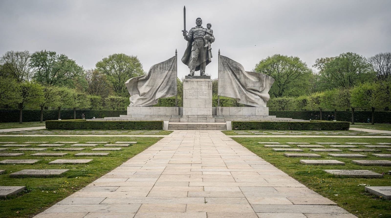
Soviet War Memorial at Treptower Park — Reich Chancellery marble
The Soviet War Memorial (Sowjetisches Ehrenmal) in Treptower Park in Treptow is one of the largest and most dramatically scaled war memorials in Europe, inaugurated in 1949. The main sculpture — a 12-metre bronze of a Soviet soldier holding a German child and with a broken swastika under his boot — stands on a base of marble from the demolished New Reich Chancellery.
When Soviet engineers demolished the Chancellery in 1945–1949, the high-quality marble cladding from Speer’s interior was reused in the construction of the memorial. Walking the red-granite-flanked approaches to the main figure, you pass between rows of white marble sarcophagi bearing quotations from Stalin — a Cold War construction, but one made literally from the physical fabric of the Nazi state.
Approximately 5,000 Soviet soldiers who died in the Battle of Berlin are buried in the memorial grounds. The scale of Soviet losses in the war — an estimated 27 million dead — is rarely adequately conveyed in Western histories of the conflict.
Getting there: S-Bahn S8/S9/S41/S42 to Treptower Park, then a 10-minute walk through the park. Free entry, open permanently.
See also the Soviet War Memorial Treptower Park guide for detailed visiting information.
Berlin Story Bunker — an accessible underground site
The Berlin Story Bunker on Schöneberger Strasse in Mitte is one of the few surviving wartime air-raid shelters (Hochbunker — above-ground reinforced concrete bunker) accessible to the public. The bunker was built in 1943 and could shelter approximately 3,000 people. It now functions as a commercial attraction with a permanent exhibition on Berlin’s history.
The exhibition includes a section on the Führerbunker and the final days of the war that uses models and original documentation. It is commercially operated and charges admission (check current pricing). It is not the Führerbunker itself — a common point of confusion.
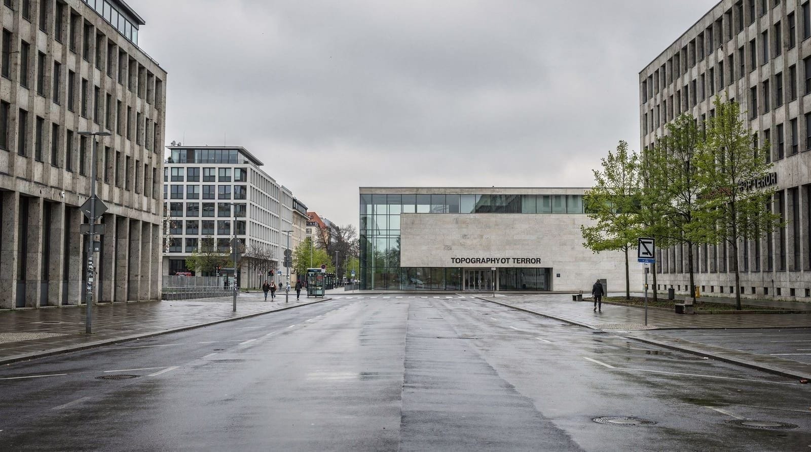
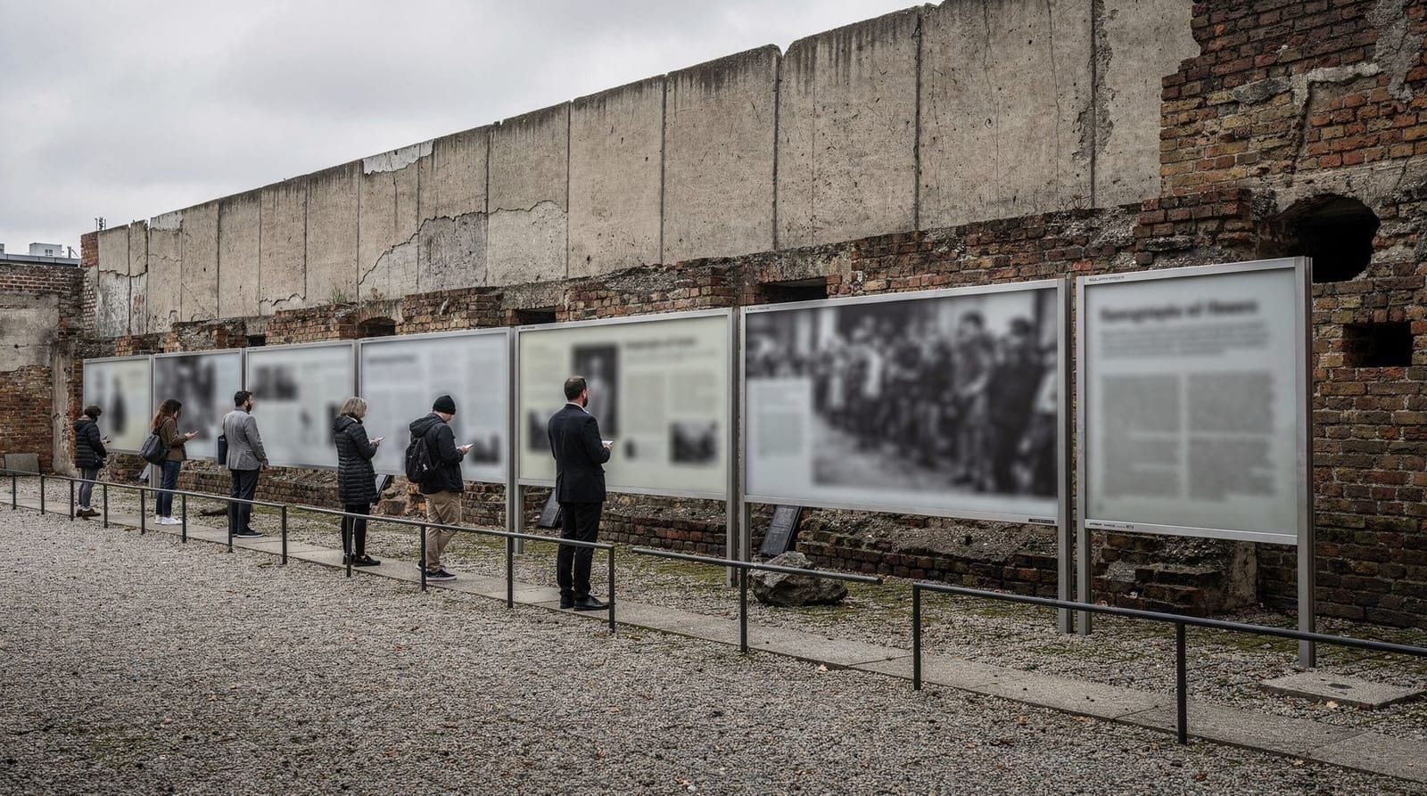
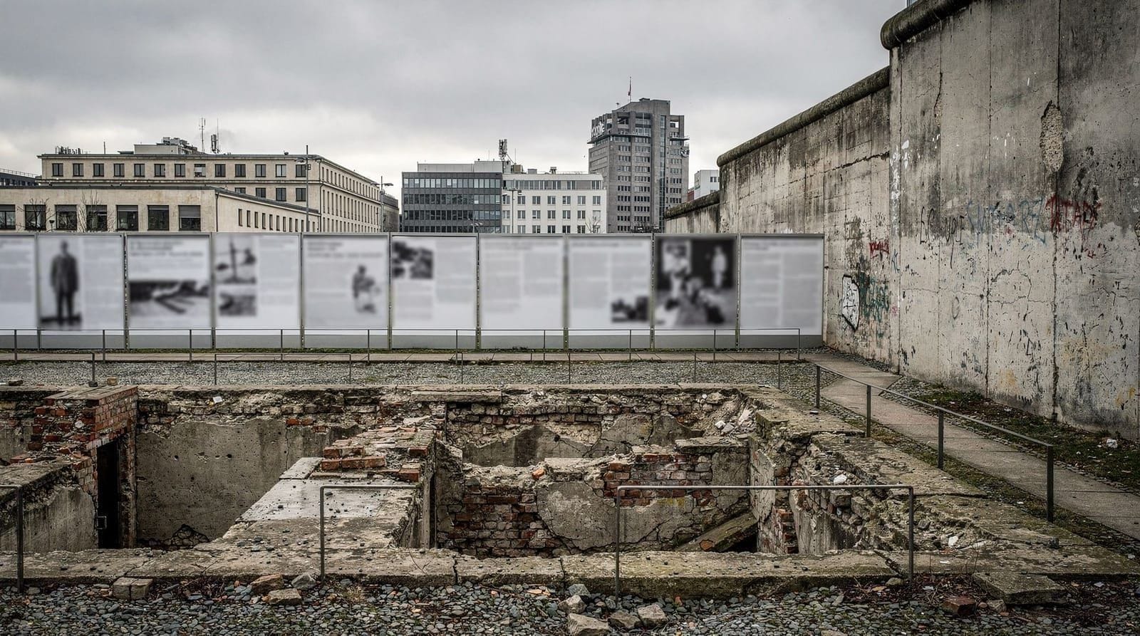
For visitors interested in bunker architecture and wartime shelter history, the Berlin Story Bunker provides access to original infrastructure. For visitors interested in the broader history, the Topography of Terror and the Holocaust Memorial information centre are more substantive resources.
What the post-war city did with its ruins
The two Berlins took different approaches to their ruins.
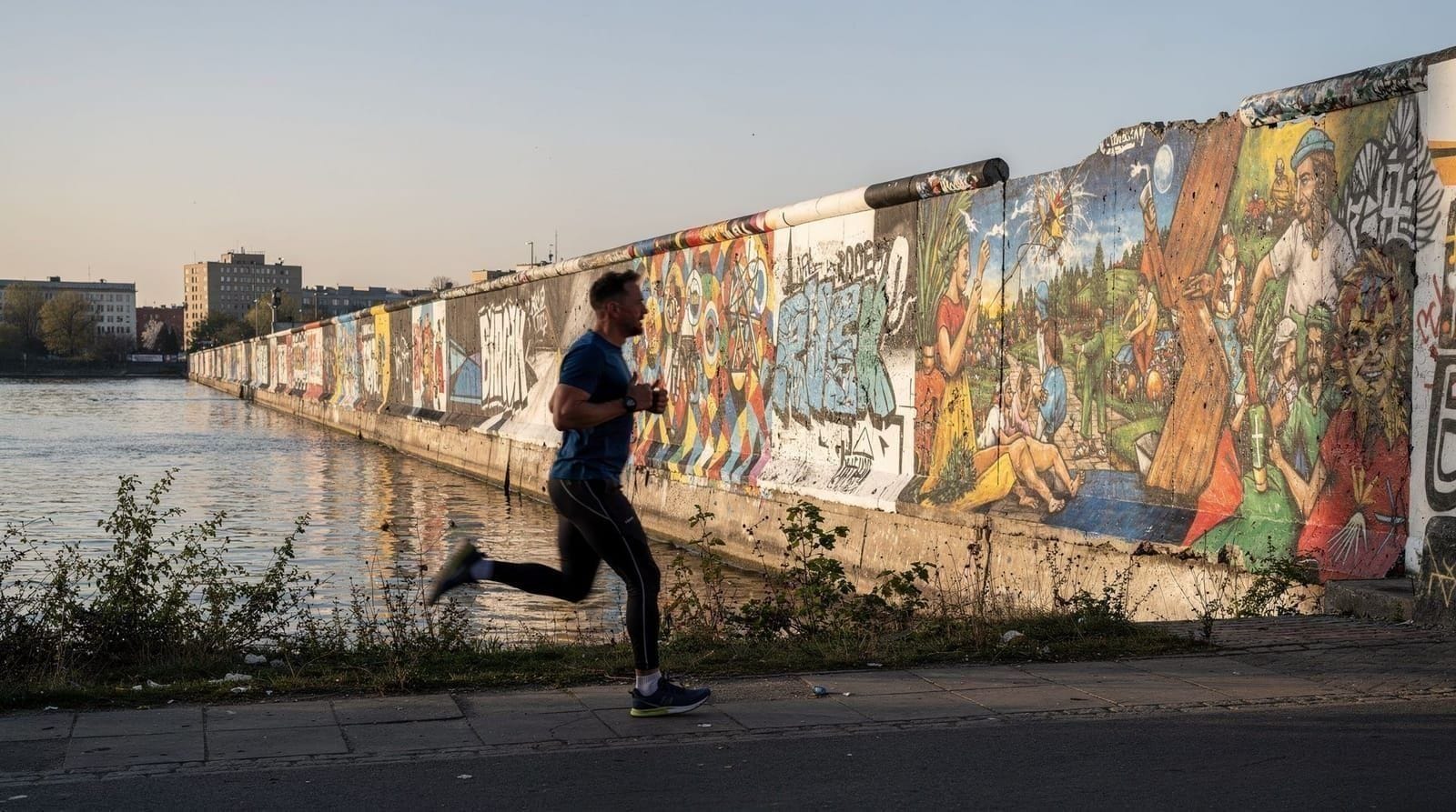
East Berlin (GDR): Certain ruins were preserved as deliberate anti-fascist monuments — the ruins of the Anhalter Bahnhof (train station), for instance, were left partially standing in the Friedrichshain district. The city’s reconstruction followed a different aesthetic: Stalin Allee (Stalinallee, now Karl-Marx-Allee), begun in 1952, imposed a Soviet neoclassical style on the rebuilt east. Ruins that could be interpreted as symbols of fascist destruction were sometimes preserved; ruins associated with Prussian or bourgeois history were cleared.
West Berlin: Reconstruction was faster and more commercially driven. The Kurfürstendamm was rebuilt quickly; the Hansaviertel was constructed as an international showcase of modernist architecture for the Interbau 1957 exhibition. Ruins were generally cleared, with the notable exception of the Kaiser Wilhelm Memorial Church.
Walking both halves of the city today, the architectural patchwork reflects these different histories. East Berlin’s Mitte contains more pre-war fabric (because less was rebuilt after the war), while West Berlin’s Charlottenburg and Schöneberg are largely post-war reconstruction.
Frequently asked questions about WWII bombing traces in Berlin
How much of Berlin was destroyed in WWII bombing?
By the end of the war in May 1945, approximately 40 percent of Berlin's building stock had been destroyed or heavily damaged, with some central districts reaching 80–90 percent destruction. The RAF and USAAF conducted a sustained bombing campaign from 1943 that hit the city repeatedly. Soviet artillery from February–May 1945 caused additional destruction. An estimated 125,000 Berliners died from bombing and the final battle.Why was the Kaiser Wilhelm Memorial Church left as a ruin?
The decision to preserve the tower ruin of the Kaiser Wilhelm Memorial Church (Kaiser-Wilhelm-Gedächtniskirche) as a permanent memorial was made in 1959–1961, after public debate about whether to demolish it entirely or restore it. Berliners informally called the damaged tower the "hollow tooth" (Hohler Zahn). The new church structures by Egon Eiermann were built alongside it, deliberately contrasting with the ruin. It has remained a memorial to the destruction of war ever since.Are bullet holes on Berlin buildings authentic or decorative?
In Mitte, Prenzlauer Berg, and Friedrichshain, many bullet holes on older (pre-1945) building facades are authentic damage from the 1945 street fighting during the Battle of Berlin. The fighting was particularly intense as Soviet forces moved building by building through the city from April 16 to May 2, 1945. Some bullet holes have been deliberately preserved; others simply remained unfilled during renovation.What happened to Berlin's WWII rubble?
Berlin generated an estimated 75 million cubic metres of rubble after the war, cleared by the Trümmerfrauen (rubble women) — teams of women, mostly widows, who manually cleared bricks for reuse. Much of the rubble was compacted into artificial hills (Trümmerberge) across the city. The Teufelsberg in the Grunewald, the Volkspark Friedrichshain's two hills, and the Insulaner in Schöneberg are all Trümmerberge — rubble mountains from WWII destruction.Where is the Teufelsberg and what is it?
Teufelsberg (Devil's Mountain) is an artificial hill in the Grunewald forest, 115 metres high, built from approximately 12 million cubic metres of WWII rubble. A US National Security Agency listening station operated from its summit during the Cold War. The station's geodesic domes are visible from the hill. Teufelsberg is now open for urban exploration visits (entry charge applies). It represents two layers of Cold War history sitting atop the physical remains of the Second World War.Which Berlin districts show the most WWII damage traces?
The most concentrated visible traces of WWII damage are in Mitte (bullet holes on pre-war Mietshaus facades, abrupt changes in building fabric), Prenzlauer Berg (many interwar buildings survived with damage), and the outer districts of Spandau and Treptow where fighting was heavy. East Berlin's reconstruction under the GDR preserved some ruins as anti-fascist monuments while obliterating others.What was the Battle of Berlin in 1945?
The Battle of Berlin was the final major offensive on the Eastern Front, running from April 16 to May 2, 1945. Soviet Marshal Georgy Zhukov's forces, with approximately 1.5 million troops, pushed from the Oder River to the city centre against a German defence of roughly 90,000 Wehrmacht and SS troops supplemented by Volkssturm (civilian militia). Block-by-block fighting destroyed much of the remaining building stock that had survived the bombing campaign. German forces surrendered on May 2; Hitler had died by suicide on April 30.