Berlin divided: the four sectors, the Wall and life in a split city 1945–1990
Berlin: East Berlin and the Wall Walking Tour
How was Berlin divided during the Cold War?
After Germany's surrender in May 1945, Berlin was split into four occupation zones — American (south-west), British (west), French (north-west), and Soviet (east). As the Cold War hardened, the Soviet sector became East Berlin, capital of the GDR, while the western three sectors merged into West Berlin, a democratic enclave surrounded by East German territory. The Berlin Wall, built from 13 August 1961, physically separated the city until 9 November 1989.
How was Berlin divided during the Cold War? After Germany’s surrender in May 1945, Berlin was split into four occupation zones — American (south-west), British (west), French (north-west), and Soviet (east). As the Cold War hardened, the Soviet sector became East Berlin, capital of the GDR, while the western three sectors merged into West Berlin, a democratic enclave surrounded by East German territory. The Berlin Wall, built from 13 August 1961, physically separated the city until 9 November 1989.
The division of Berlin: from rubble to iron curtain
Berlin in May 1945 was a city of ruins. The Soviet army had fought its way through the eastern districts building by building during the final weeks of the Second World War, and the combined effect of Allied strategic bombing and close-quarters urban fighting had left the city centre looking like a quarry. Estimates suggest that 16 cubic metres of rubble existed for every person still living in Berlin at the war’s end. The population had fallen from a pre-war peak of 4.3 million to under 3 million, with hundreds of thousands dead, displaced, or fled.
It was this shattered city that the four victorious powers — the United States, Britain, France, and the Soviet Union — agreed to administer jointly. The agreements had been reached in principle at the Tehran Conference in 1943 and formalised at Yalta in February 1945. The specific boundaries of the Berlin sectors were determined by the European Advisory Commission, which had been working on post-war planning since 1943. The Soviet army, which took Berlin in early May, withdrew from the agreed western zones and allowed Western forces to move in during July 1945.
The formal administrative framework was established at the Potsdam Conference, held in July and August 1945 at the Cecilienhof Palace in what would become part of the Soviet zone — a detail whose irony was not lost on observers at the time. The four powers agreed to govern Germany and Berlin jointly through the Allied Control Council and the Allied Kommandatura in Berlin, with decisions to be taken by consensus. It was an arrangement that contained the seeds of its own failure: any one power could block any decision. The Soviet Union began using this veto systematically as Cold War tensions hardened through 1947 and 1948.
The crisis point came in 1948. In June of that year, the Western powers introduced a new currency, the Deutsche Mark, in their zones — a move designed to restart the West German economy and end the barter chaos that had prevailed since 1945. The Soviet Union, seeing this as a unilateral move that undermined the framework for joint administration, responded on 24 June 1948 by blocking all road, rail, and canal access from West Germany to West Berlin. West Berlin — an island of 2.2 million people 170 km inside Soviet-controlled territory — was to be starved into submission.
What followed was the Berlin Airlift. For 324 days, the Western powers flew supplies into Tempelhof airport in the American sector (and later Gatow in the British sector and Tegel in the French sector) to sustain the city. At its peak, an aircraft was landing in West Berlin every 45 seconds around the clock. The operation delivered more than 2 million tonnes of coal, food, and other supplies. The Soviet blockade was lifted in May 1949 after it became clear it would not work. The airlift is commemorated at Tempelhof — the former airfield is now a public park, with the original terminal building preserved and open for tours.
The four allied sectors — where they were
The boundaries between the four sectors were not arbitrary. They followed existing district (Bezirk) lines, which had been established under the Weimar Republic’s 1920 restructuring of Greater Berlin.
The American sector covered the south-western districts: Tempelhof, Neukölln, Kreuzberg, Schöneberg, Zehlendorf, and Steglitz. This gave the Americans control over Tempelhof airport — a significant asset — and the working-class neighbourhoods of Kreuzberg and Neukölln, which would become centres of counterculture in the 1970s and 1980s.
The British sector lay to the west and north-west, covering Tiergarten (including the zoo and the Hansaviertel), Charlottenburg (the pre-war commercial heart of the city), Spandau (the site of the military prison where Rudolf Hess was held until 1987), and Wilmersdorf. The British operated a major signals intelligence facility at the RAF Gatow air base in Spandau.
The French sector covered the northernmost districts: Wedding and Reinickendorf. The French were the smallest military power among the Western three, and their sector reflected this — Wedding and Reinickendorf were solidly working-class residential areas without major symbolic significance. The French built a new airport at Tegel in 1948 specifically to support the airlift; it became West Berlin’s main civilian airport and operated until 2020.
The Soviet sector covered the entire eastern portion of the city: Mitte (the historic centre, including the Brandenburg Gate, Unter den Linden, and Museumsinsel), Prenzlauer Berg, Friedrichshain, Lichtenberg, Treptow, and the other eastern Bezirke. This meant the Soviets held the symbolic and administrative heart of the pre-war German capital — the Reichstag (badly damaged), the government quarter, and the main commercial thoroughfares.
After 1949, when the Federal Republic of Germany was established in the west and the German Democratic Republic in the east, the western sectors became “West Berlin” — formally a separate entity not part of the Federal Republic, though deeply integrated with it economically and politically — and the Soviet sector became “East Berlin,” which the GDR designated as its capital. The Western powers never formally recognised East Berlin’s status as the GDR capital, maintaining throughout the Cold War that the four-power status of the city as a whole remained legally in force.
The refugee crisis and the decision to build the Wall
Between 1949 and 1961, approximately 3.5 million people left East Germany for the West. This was not a small trickle of political dissidents; it represented more than one-fifth of the entire GDR population. And the escape route, for most of those years, ran directly through Berlin.
The inner-German border — the 1,393 km line between West Germany and East Germany — was progressively sealed from 1952 onward. Barbed wire, watchtowers, and mines made crossing it on foot extremely dangerous. But Berlin was different. Under four-power agreement, civilians were still permitted to move between the sectors. An East German could travel to East Berlin by train, cross into West Berlin on the U-Bahn, walk into a West Berlin registration office, and be on a flight to West Germany within days.
This loophole was catastrophic for the GDR. The people leaving were not, on average, the elderly or the unskilled. The emigration disproportionately took doctors, engineers, teachers, and managers — exactly the professionals the East German economy needed to function. By 1960-61, the brain drain was acute enough that some hospitals were operating at half capacity because their medical staff had left. Agricultural collectivisation, which had accelerated in 1960, drove further flight from the countryside.
The summer of 1961 brought matters to a head. In July 1961, 30,000 people left East Germany through Berlin. In the first twelve days of August, another 16,000 left — a daily rate that would have stripped the GDR of a quarter million people in a year. Walter Ulbricht, the SED First Secretary, had been requesting Soviet permission to close the border since at least 1960. On the night of 12-13 August 1961, Nikita Khrushchev gave the order.
At midnight, East German troops and police began sealing the sector boundaries with barbed wire. Railway and U-Bahn connections between the sectors were cut. By morning, the city was divided. West Berliners woke to find the crossing points blocked. Families who had lived on opposite sides of what were now sector lines were separated overnight.
The West’s response was measured — even, in the view of many West Berliners, inadequate. Willy Brandt, the governing mayor of West Berlin, protested publicly and urgently but received only cautious sympathy from the Kennedy administration, which had concluded that the Wall, however ugly, was preferable to the alternative: Soviet military action to absorb West Berlin entirely. Kennedy’s famous remark in private was that “a wall is a hell of a lot better than a war.”

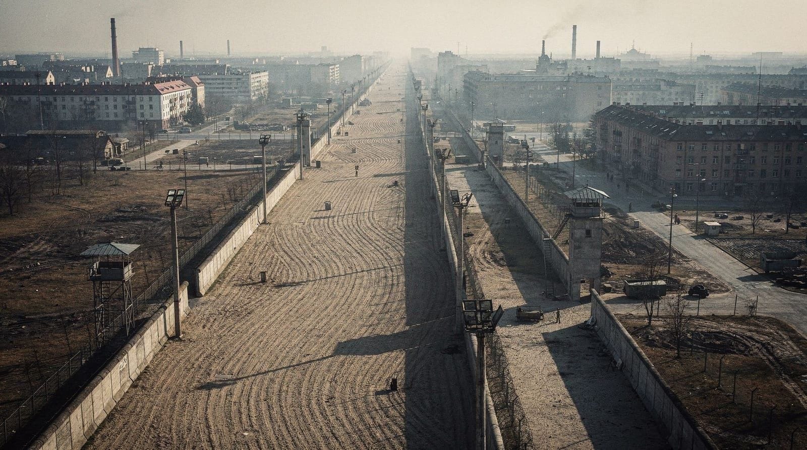
The Wall: construction, evolution and the death strip
The initial barrier of August 1961 was barbed wire strung along the sector line. It was militarily crude but operationally effective — the wire could be laid in hours, and it stopped the flow of refugees almost immediately. In the weeks and months that followed, the wire was replaced with concrete blocks, then with a more sophisticated wall system, and finally — by 1975 — with the definitive structure that most people associate with the phrase “the Berlin Wall.”
The mature Wall was not one barrier but a system. Starting from East Berlin and moving towards the west:
First came the inner fence — a lighter metal mesh fence that marked the eastern limit of the prohibited zone. East Berliners were not permitted to approach within a certain distance of this fence without special authorisation. Behind it, on the East Berlin side, were the military access roads used by patrols.
Then came the death strip (Todesstreifen). This was the defining feature of the border system — a band of raked sand or gravel, lit by arc lights powerful enough to read by, flanked by anti-vehicle trenches and dog runs. Its width varied from 30 metres in narrow urban streets to 150 metres in open areas on the city outskirts. SM-70 self-firing devices — spring-loaded shotgun mechanisms triggered by tripwires — were installed along sections of the death strip from 1971 onwards; they were eventually removed in 1983-84, partly because they posed a risk to East German border soldiers.
Guards patrolled the death strip in pairs, under orders not to allow an unauthorized crossing. The rules of engagement evolved over time: the shoot-to-kill order was most explicit in the early years and became somewhat more ambiguous in the 1980s, partly due to international pressure after several high-profile deaths. But the practical reality did not change significantly.
Finally came the outer Wall — the side facing West Berlin — which was 3.6 metres high, made of precast concrete segments with a rounded pipe cap at the top to prevent grip. This is the side that West Berliners painted and covered with murals. The iconic graffiti images that survive in photographs are all on the western face; the eastern face was plain white, to make footprints and any climbing equipment immediately visible.
The total length of the barrier system surrounding West Berlin was 155 km, of which 43 km ran through the city itself. There were 302 watchtowers positioned along the Wall system, 20 bunkers, and 259 dog runs. The cost of maintaining this apparatus — guards, equipment, surveillance — consumed a significant fraction of the GDR’s security budget every year it stood.
Life in West Berlin 1961–1989
West Berlin after the Wall was built was in some respects a beleaguered city and in others a remarkably vibrant one. The immediate practical reality was stark: it was an island. To reach West Germany by land, West Berliners had to drive or take the train through East German territory, submitting to border checks at the transit corridor crossings. The Autobahn to Helmstedt and the railway to Hanover were the main routes; delays at the transit checkpoints were routine and sometimes deliberately extended.
To compensate for the economic disadvantages of this isolation — the uncertainty that discouraged business investment, the limited land supply, the logistical complications — the Federal Republic subsidised West Berlin heavily. Tax breaks encouraged workers to remain; federal agencies were deliberately placed there; cultural institutions including the Berliner Philharmoniker and multiple major museums received generous federal funding. The city’s universities attracted students partly because West Berliners of military age were exempt from the Federal Republic’s military service requirement.
The result was a city with an unusual demographic profile. Young people, students, artists, and political radicals disproportionately chose West Berlin in the 1960s and 1970s. The student movement of 1968 was particularly intense in West Berlin, partly because of the political context and partly because the contained, pressurised nature of the city made political confrontation more visible. The squatter movements of the early 1980s — Hausbesetzer who occupied empty buildings in Kreuzberg — grew in a city where the housing market worked differently than anywhere else in West Germany.
The music connection is real and not overstated. David Bowie and Iggy Pop both lived in West Berlin in 1976-79, Bowie in Schöneberg and Iggy in a shared apartment in the same neighbourhood. Bowie recorded his “Berlin Trilogy” — Low, Heroes, and Lodger — partly at Hansa Studios near the Wall on Potsdamer Platz. Heroes was recorded with a microphone placed 20 metres from the studio and another at the far end of the room, picking up the ambient sound of the city. The Wall is audible, in a sense, in the reverb of that album.

Life in East Berlin (the GDR capital)
East Berlin occupied a contradictory position within the GDR. It was the capital and the regime’s showcase — the city that the government wanted foreign visitors to see, the city that received preferential supply allocations, the city where the most prestigious cultural institutions were concentrated. It was also a city under surveillance, where the Stasi maintained its largest concentration of resources, and where the consequences of deviation from approved behaviour were most directly felt.
The material conditions of East Berlin were, by GDR standards, genuinely better than most of the country. Consumer goods were more available; the range of food in the shops was wider; cultural life — theatre, cinema, classical music — was richer. Rents were artificially suppressed to a small fraction of income; public transport was cheap and reliable; bread and basic foodstuffs were heavily subsidised. Job security was essentially absolute, since the GDR did not permit unemployment in the Western sense.
Against this, the constraints were real and pervasive. Travel to Western countries was essentially impossible for ordinary East Berliners; the exceptions — senior party members, pensioners who were seen as no longer economically valuable and therefore permitted to visit the West — were a small minority. Consumer goods beyond the basics were scarce: waiting lists for a Trabant automobile ran to ten years in the 1980s. The apartment allocation system meant that where you lived was to a significant degree determined by your employer and political reliability.
The Stasi presence in East Berlin was more intense than anywhere else in the GDR. The headquarters were in Lichtenberg; the district offices were distributed throughout the city; the informant network (one registered unofficial collaborator for every 63 citizens across the GDR as a whole, and likely denser in the capital) extended into every workplace, housing block, and social circle. Our Stasi Museum guide covers the surveillance apparatus in detail.
Cultural life under the GDR was not entirely grey. East Berlin had a genuine theatre tradition — the Deutsches Theater and the Berliner Ensemble (Brecht’s company) were serious international institutions. Rock music, officially discouraged, developed an underground following that the regime eventually licensed in heavily controlled form. Literature existed in constant negotiation between writers, publishers, and the cultural ministry; some remarkable work was produced within those constraints.
The physical landscape the GDR built in East Berlin still shapes the city. Karl-Marx-Allee — the Stalinist boulevard built in the 1950s with its palatial residential blocks — runs from Frankfurter Tor to Alexanderplatz. The Fernsehturm (TV Tower) at Alexanderplatz, completed in 1969, was a deliberate assertion of GDR technological achievement; at 368 metres it remains the tallest structure in Germany. The Palast der Republik, the GDR’s parliament and cultural centre that replaced the bombed-out Berliner Stadtschloss, was demolished after reunification; the reconstructed Stadtschloss (now housing the Humboldt Forum) stands in its place.
For a thorough account of GDR everyday life, see our guide to life in East Germany under the DDR.
Escape attempts across the Wall
In the first weeks after the Wall went up in August 1961, the barrier was porous enough that determined people could still get through. Border guards — young men under orders — occasionally looked the other way, or were overcome, or were themselves among the escapees. Conrad Schumann, a 19-year-old East German border policeman, was photographed on 15 August 1961 jumping over the barbed wire in his uniform — one of the most reproduced photographs of the Cold War.
As the barrier hardened, escape methods became more elaborate and more dangerous. Underground tunnels were dug from West Berlin into the East; the most ambitious, Tunnel 57, was completed in October 1964 and allowed 57 people to escape before East German border troops discovered it. Car escapes using hidden compartments — a false floor beneath the back seat, a space behind a dashboard — were used throughout the 1960s; a cottage industry of professionals who supplied modified cars operated from West Berlin. Small boats crossed the Spree and the canal network in the early years, though the waterways were increasingly monitored.
In 1979, a family built a hot-air balloon from material acquired over two years and flew it across the border — not exactly the Wall in Berlin but across the inner-German border in Thuringia. The escape took 28 minutes and covered approximately 28 km before landing safely in the West. Two families, eight people, survived a failed attempt four months earlier.
The deaths at the Wall are documented individually by the Berlin Wall Memorial Foundation. Peter Fechter, an 18-year-old bricklayer, was shot while attempting to cross near Checkpoint Charlie in August 1962. He fell wounded into the death strip and lay visible from both sides for approximately 50 minutes, calling for help, before dying. East German border guards did not retrieve him; West Berliners and American soldiers watching from their side could not cross into the strip without triggering an international incident. His death became one of the most reported episodes of the Wall’s existence.
The guards who shot at escapees were, under GDR law, acting within their orders and were immune from prosecution while the GDR existed. After reunification, a series of trials was held for border guards whose actions had led to deaths; the Federal Republic’s Supreme Court ruled in 1992 that the GDR’s shoot-to-kill orders were unlawful under general principles of international law, and several guards were convicted — though most received suspended sentences. The commanding officers who issued the orders faced more serious charges.
The surviving watchtowers along the former Wall line give a physical sense of the observation infrastructure that made unauthorised crossing so difficult.
The fall of the Wall, 9 November 1989
The Wall did not fall in isolation. By the autumn of 1989, the GDR was under pressure from multiple directions simultaneously. In May 1989, Hungary had begun dismantling the fence on its border with Austria — the first breach in the Iron Curtain. Within weeks, East Germans on holiday in Hungary began crossing through. By September, the Hungarian government formally opened the border; more than 30,000 East Germans used it to reach Austria and then West Germany in September alone.
Inside the GDR, mass demonstrations had been building since late summer. Leipzig’s Monday demonstrations, which began with a few hundred people gathering at the Nikolaikirche and grew to 70,000 by 9 October, showed that large public protest was possible — and that the security forces were not going to massacre the crowds. Erich Honecker, the SED General Secretary who had been in power since 1971, was replaced by Egon Krenz on 18 October. The pressure on the regime continued.
On the afternoon of 9 November, the SED Politburo approved a new travel regulation that would allow East Germans to apply for exit visas. The regulation was supposed to come into effect the following day and require application through official channels. Günter Schabowski, the Politburo spokesman who was assigned to announce it at the 6:00 pm press conference, had not attended the meeting where the details were discussed and had not read the full document carefully.
At 18:53, an Italian journalist asked when the new travel rules would take effect. Schabowski shuffled through his papers and said, without evident awareness of the significance: “Immediately, without delay.” He added that this applied to all crossings, including those into West Berlin.
The press conference was broadcast live. Within an hour, crowds had gathered at every checkpoint in Berlin. At Bornholmer Strasse — the first checkpoint to open, at around 23:30 — the chief border officer, Harald Jäger, made the decision to open the gates when the crowd became too large to hold back and he could get no coherent instructions from his superiors. People streamed through. Within hours, all checkpoints were open, and crowds were gathering on the Wall itself, beginning the physical process of taking it apart with hammers and chisels.
The formal reunification of Germany followed on 3 October 1990 — less than a year after the Wall fell.

Where to trace divided Berlin today
The physical evidence of the division is more present in Berlin than is sometimes assumed. The Wall itself — of which roughly 3 km survives in protected form — is the most direct relic, but the division shaped the urban fabric in ways that remain visible decades later.
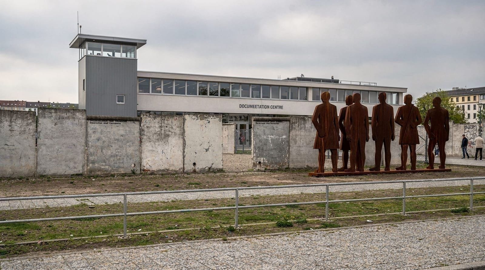
The Berlin Wall Memorial on Bernauer Strasse is the most historically intact surviving site. An 80-metre section of the original Wall stands with the death strip behind it, a watchtower, and ground-level markers showing where apartment buildings once stood — the residents were forcibly removed in 1961 when the Wall bisected their street. The documentation centre adjacent contains photographs, survivor testimonies, and a chronological exhibition. Entry is free; it is outdoors and accessible at all hours. Our Berlin Wall Memorial Bernauer Strasse guide has the full detail on what to see.
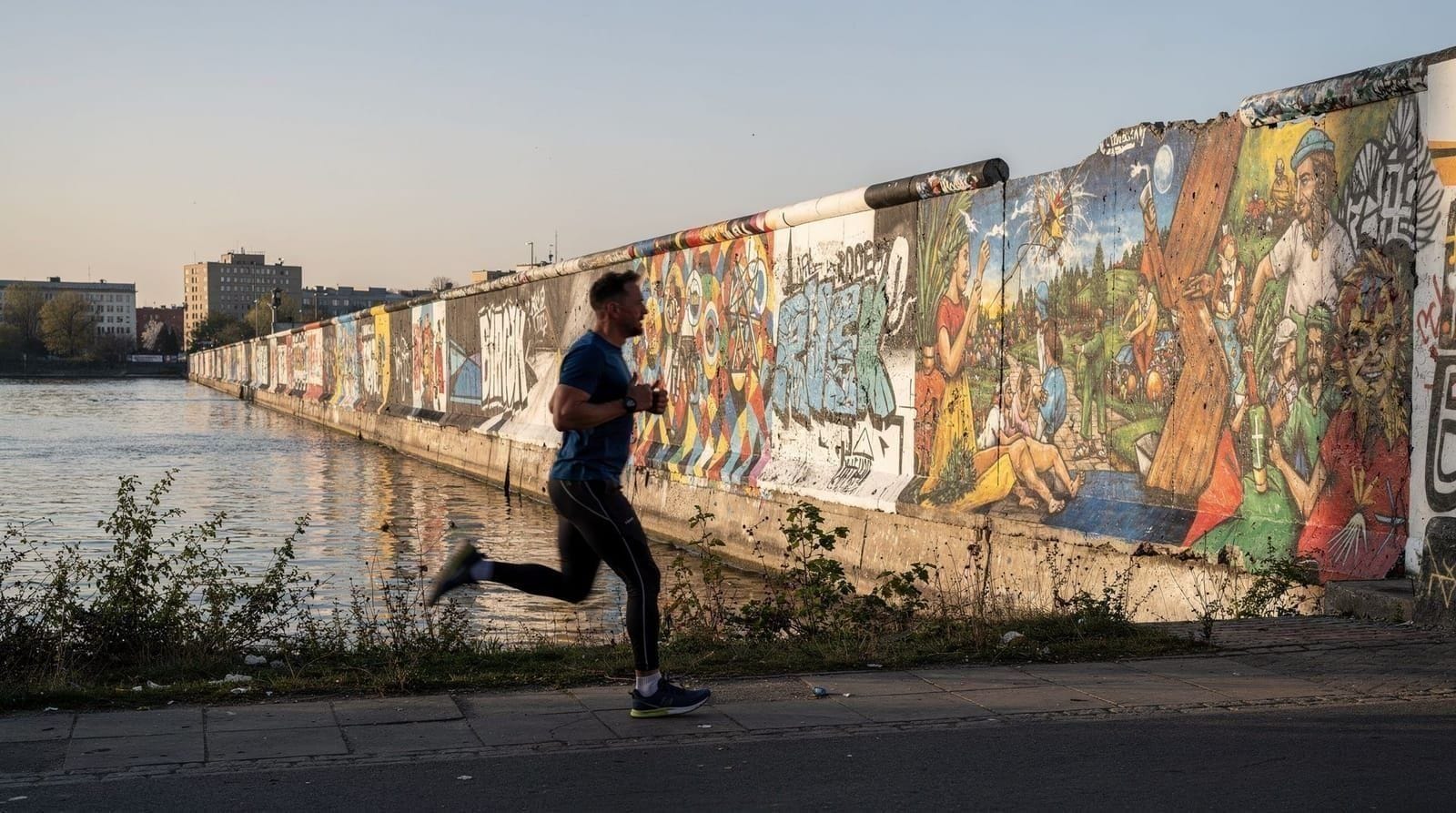
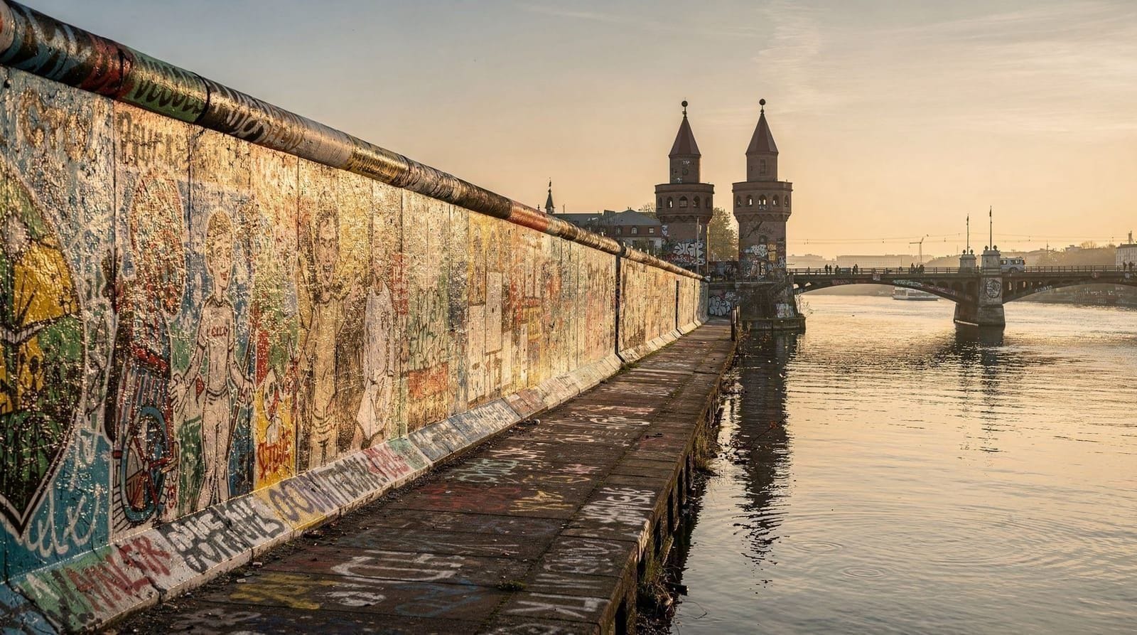
The East Side Gallery in Friedrichshain is the longest surviving painted stretch of the outer Wall — 1.3 km of concrete segments covered with murals painted in 1990 by international artists. It is a different experience from Bernauer Strasse: festive rather than solemn, a collective art project rather than a memorial. Several segments have been replaced or repainted over the years. See our East Side Gallery guide for a walk-through of the notable murals and their history.
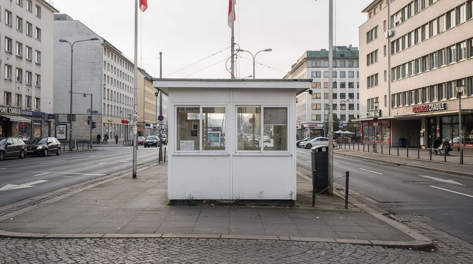
Checkpoint Charlie is heavily commercialised — actors in US military uniforms pose for photographs for tips, souvenir shops line the pavements — but the free outdoor exhibition boards surrounding the former crossing point are informative and worth reading. The Haus am Checkpoint Charlie museum charges 14.50 euros for an extensive if somewhat chaotic exhibition on escape attempts. Our Checkpoint Charlie guide gives an honest assessment of what is worth your time.
The Topography of Terror on Niederkirchnerstrasse documents the Gestapo, SS, and Security Service that operated from buildings on this site, with strong coverage of how their methods fed into the post-war Stasi. It is free, open daily, and particularly valuable for understanding the institutional continuities between Nazi and Communist state security systems.
The DDR Museum on the Spree near Museumsinsel offers hands-on exhibits on GDR everyday life — a Trabant you can sit in, a reconstructed socialist apartment, the Zersetzung files. It charges 12.50 euros and is particularly useful for visitors who want to understand the texture of daily life rather than political chronology.
Practical information for visiting Cold War Berlin sites
All major sites are accessible by public transport without needing a taxi or rental car.
Bernauer Strasse Memorial: U8 to Voltastrasse, or tram M10 to Gedenkstätte Berliner Mauer. Open daily; documentation centre closes at 18:00 (20:00 in summer). Free.
East Side Gallery: S-Bahn to Ostbahnhof or Warschauer Strasse, then a 5-minute walk. Freely accessible 24 hours; the murals are on the exterior of the Wall section along the river.
Checkpoint Charlie: U6 to Kochstrasse. Free outdoor exhibition 24 hours. The Haus am Checkpoint Charlie museum opens daily from 09:00 to 22:00; 14.50 euros.
Topography of Terror: Walk from Checkpoint Charlie (10 minutes north along Wilhelmstrasse), or U2 to Potsdamer Platz and walk south. Free; open daily 10:00-20:00.
DDR Museum: Karl-Liebknecht-Strasse 1, near Museumsinsel. U5 to Rotes Rathaus or S-Bahn to Hackescher Markt. Open daily; 12.50 euros.
For a complete day or multi-day circuit of the main sites, the Cold War Berlin itinerary sequences them by location to minimise travel time. A guided walking tour is worth considering for first-time visitors: the geography of the division is easier to grasp with someone who can point out street corners and explain what stood where. The Berlin destination guide covers transport and logistics for the city as a whole.
The espionage dimension of the division — the tunnels, the spy swaps, the surveillance apparatus — is covered in our companion guide to Cold War espionage in Berlin. For the complete Berlin Wall history, including all surviving sections and the full chronology of the Wall’s construction and fall, see the dedicated guide.
Frequently asked questions about Berlin divided
When was the Berlin Wall built and why?
The Berlin Wall was built starting on 13 August 1961. The East German government (backed by the Soviet Union) constructed it to stop the mass emigration of East Germans to the West through Berlin — between 1949 and 1961, roughly 3.5 million people had left the GDR, including many skilled workers and professionals. The Wall was initially barbed wire and quickly became a concrete barrier with a heavily fortified death strip.How many people died trying to cross the Berlin Wall?
Estimates vary, but the most rigorous research by the Berlin Wall Memorial Foundation counts at least 140 people killed at the Berlin Wall itself. Including deaths at other inner-German border crossings and related circumstances, the total is considerably higher. The youngest victim at the Wall was a 15-year-old boy; the last killing occurred in February 1989, nine months before the Wall fell.When did the Berlin Wall fall?
The Wall fell on 9 November 1989. A GDR spokesman's confused press conference announcement that East Germans could cross the border "immediately, without delay" triggered crowds gathering at crossing points. Guards, with no clear orders, eventually opened the gates. The physical demolition of the Wall took place over following months; reunification of Germany occurred on 3 October 1990.What was the death strip?
The death strip (Todesstreifen) was the no-man's land between the inner Wall (facing East Berlin) and the outer Wall (facing West Berlin). It was raked sand (to show footprints), lit by floodlights, patrolled by guards with dogs, and covered by tripwire automatic firing devices (SM-70 mines) on the eastern side. Guards had shoot-to-kill orders. The strip varied from 30 to 150 metres wide.Where can I see the most authentic surviving section of the Berlin Wall?
The Berlin Wall Memorial on Bernauer Strasse preserves an 80-metre section of the original Wall with the death strip, a watchtower, and the foundation outlines of demolished houses — residents were forcibly evacuated when the Wall bisected their street in 1961. The memorial is free, outdoors, and the most historically complete site. A documentation centre with photographs and survivor testimonies is adjacent.What was daily life like in East Berlin?
East Berlin was the capital and showcase of the GDR, better supplied than most East German cities but still subject to shortages, political surveillance, restricted travel, and compulsory participation in state structures. Workers paid low rents and had job security, but consumer goods were scarce and the choice of where to live or work was controlled. The DDR Museum near Museumsinsel offers hands-on exhibits on everyday GDR life.Where were the four sector borders in Berlin?
The American sector covered Tempelhof, Neukölln, Kreuzberg, Schöneberg, Zehlendorf, and Steglitz — broadly the south-west. The British sector covered Tiergarten, Charlottenburg, Spandau, and Wilmersdorf. The French sector covered Wedding and Reinickendorf in the north. The Soviet sector covered the eastern districts including Mitte, Prenzlauer Berg, Friedrichshain, Lichtenberg, and Treptow.What is the Glienicke Bridge connection to divided Berlin?
Glienicke Bridge over the Havel river at the Potsdam border was one of the few points of crossing between West Berlin and East Germany. Because it connected to Potsdam (Soviet sector / GDR), it was used for Cold War spy exchanges — including the 1962 swap of U-2 pilot Francis Gary Powers for Soviet spy Rudolf Abel. The bridge is freely accessible and a 30-minute tram or taxi ride from Wannsee S-Bahn station.
Top experiences
Bookable activities with verified prices and instant confirmation on GetYourGuide.